THE PROJECT

OBJECTIVES

The project aims at creating an international collaborative community, expert in remote sensing soil and vegetation, risk management and mitigation, to provide climate information along with decision makers and planning authorities in order to:

Increase efficiency of decision and policy makers authorities response, to improve the preparedness level of our societies and to limit the high economic cost of climate variability impact on fire and post fire risks, develop methods and procedures within the framework of fire and post fire risk management in Europe at climatic time scales.

Strengthen the science-policy-society nexus using a participatory approach, by improving operational or experimentally tested climate services in Europe, tailoring relevant information for decision and policy makers through a participatory and circular approach, capacity building user-based tools, specific training programs, dissemination activities.

Increase the information regarding the drought conditions on wildfire and post fire risks management at climatic time scales for national and local authorities decision-making procedures and planning activities.

Investigate adaptation strategies and approaches to deal with future fire occurrence.

Collect scenarios on the effects of climate change on vegetation and fire occurrence.

SERV_FORFIRE consortium

The synergic and complementary activities of all the partners involved in the SERV_FORFIRE  consortium will lead to the development of an improved and integrated “fire and post fire” product portofolio.

Copernicus Climate Change Service

Copernicus Climate Change Service will routinely deliver for fire management with specific  reference to satellite data and products as in the case of EFFIS from JRC.

Partner and PI

The consortium is made by partners whose scientific missions and interests are complementary and the inter- and transdisciplinary research collaboration is very important for the Institutional integration, for the current project and future joint activities.

CNR

Research National Council of Italy, Department of Earth systems science and environmental technologies (CNR DTA)

CNR-DTA conducts studies based on the observation of the Earth and on the comprehension of chemical, physical and biological processes governing our planet. In these areas, it is the fundamental reference point for Italian and European policies. The activities range from climate and atmospheric studies to research on aquatic and terrestrial systems and the comprehension of the environmental evolution even through the analysis of data and their implementation into mathematic models. The following four Institutes of DTA are involved in the SERV_FORFIRE. (i) IMAA scientific mission is the integration of analysis and modeling for risk monitoring. It is responsible for the management and dissemination (WP 1 and WP6) and contributes to all WPs; (ii) IRET (ex IBAF) scientific mission is the forestry and vegetation monitoring provides contribution on the assessment of the impact of climate change on vegetation proneness to fire and on effects of fire itself on the ecosystem processes and biogeochemical cycles (particularly WP3 and WP4);

(iii) IBIMET mainly focuses on drought forecasting at seasonal up to climatic scale (WP2, WP5); (iv) IRSA mainly focuses on post fire monitoring (WP4); (v) IGG implements statistical investigation on fire catalogues and landslide catalogues (WP3 and WP4).

LPI : Rosa Lasaponara (CNR-IMAA)

Istituto di Metodologie per l’Analisi Ambientale, Consiglio Nazionale delle Ricerche (CNR-IMAA)

Rosa Lasaponara (degree in electronic engineering, master in engineering of the territory (Thesis 1994 on the use of GIS for fire monitoring: the case study of Ionian coast area), PhD in methods and technologies for environmental monitoring (Thesis 1998 on the use of satellite data for fire detection and risk monitoring). She is the scientific director of the laboratory of ARGON CNR- IMAA. She has over twenty years of experience in the field of the study of space technology by active satellite (radar) and passive (optical and microwave) and airborne (hyperspectral and lidar). Her research deals with optical data and radar data processing, historical data with particular reference to satellite data for the extraction of useful information for risk estimation and mitigation and land degradation. She is the LPI of SERV_FORFIRE project, funded under the ERA4CS Joint Call on Researching and Advancing Climate Services Development by Institutional integration. She has authored or co-authored more than 300 peer- reviewed work. She has been and currently is scientific coordinator of several research projects at national and international level, funded by the EU, by ASI, CNR, ESA, the DPC. She has been co-investigator in EU projects in the FP6 and FP7, and currently is PI for IMAA of BEYOND: “Building a Centre of Excellence for Earth Observation based monitoring of Natural Disasters in South-Eastern Europe” (Project GA number: 316210), which is funded under the FP7 REGPOT 2012-2013 call.

FMI

Finnish Meteorological Institute

The FMI is a research and service agency under the Ministry of Transport and Communications. FMI offers large range of quality weather services and consulting services. FMI researchers produce some 300 publications annually, the majority of them in international scientific journals. The Weather and Climate Change Impact Research (former Climate Services) at the Finnish Meteorological Institute does climate change impact research to support in climate change adaptation and risk assessments. The units’ research activity focuses on weather extremes, their impacts, variability, predictability and change and promote tailoring the weekly to monthly forecasts for the public. This involves a highly multidisciplinary research and it ties weather, climate and socio-economic research together in close collaboration with the stakeholders. The unit comprises of three research groups: Climate Change and Extreme Weather, Seasonal and Climate Applications, Socio-economic Impact Research and the staff consists of about 35 experts. The Seasonal and Climate Applications group is in charge of piloting and developing operational weather and climate models as well as forecast methods, which focus on weather changes and climate impacts.

Atmospheric composition research unit studies and observes the physical and chemical properties of aerosol particles and trace gases effecting to climate and air quality. The main research themes of the unit are the physical properties, composition, and chemical transformation of fine particles, organic compounds in the atmosphere and their analysis methods and development of air quality models and model validation. The Atmospheric Dispersion Modelling group is involved in modelling of atmospheric compounds in micro to global scales. The group develops and evaluates the full range of air pollution dispersion, exposure, and emission models, and other mathematical modelling techniques (such as CFD modelling).
LPI : Andrea Vajda (FMI)

Andrea Vajda is a Senior Research Scientist at the Finnish Meteorological Institute working in the Seasonal and Climate applications group of the Weather and Climate Change Impact Research unit. She received an MSc degree in Geography (1998) from Babes-Bolyai University (Cluj-Napoca, Romania) and PhD in Geography from the University of Helsinki in 2007 in the topic of influence of natural conditions and impact of human activities on the spatial variation of climate in Lapland. She has 20 years experience in climate research with expertise in climate change impact research, extreme weather and seasonal forecast applications. She has been leading the Climate Application group in FMI during 2015-2017 and FMI’s seasonal forecast strategy implementation work during 2016-2018. Vajda has been acting as PI for FMI in several EU projects (FP7 RAIN, Copernicus Climate Change Service Clim4Energy, ERA4CS SERV_FORFIRE), leading several working tasks in international projects (ERA4CS INDECIS – FMI’s seasonal work, EU H2020 E-SHAPE) and co-leading the national project CLIPS (2016-2017). She has published 14 peer-reviewed articles and over 60 scientific papers.

BRGM

Bureau de Recherches Géologiques et Minières

Within the BRGM department in charge of natural risks, the Mass Movements and Erosion Risks unit (RIG) studies in particular gravitational risks, concerning both the understanding and monitoring of processes, and the definition of methods for producing hazard and vulnerability maps. Regarding the subjects of slope erosion and sediment transfer, the RIG unit develops a range of different modelling approaches from physically-based modelling approach for use at the local scale, to conceptual modelling at the scale of major drainage basins, and for varying time and climate resolutions. Among the recently completed or ongoing projects concerning the proposed subject matter, we can cite the ANR (French National Research Agency) MESOEROS (Vulnerability of Mediterranean soils to changes in climate and land-use) and BIOCRUST (Modelling the impact of soil-surface colonization by microorganisms in a Sahel

environment on runoff and erosion processes) ones, and the European projects DIGISOIL (Digital Cartography of soil vulnerability), VERSEAU (Calculating sediment flux and modelling sediment connectivity within large drainage basins) and INCERTITUDES (Study of the epistemic and parametric uncertainties in erosion modelling). In the framework of this proposal, the RIG team will adapt to the context of this study several slope-erosion models (soil type and land use) developed for Temperate and arid environments. This project will also serve for developing methods of coupling socio-economic and environmental processes.

LPI: Olivier Cerdan (BRGM)

Olivier Cerdan is a researcher and head of the Mass movement and Soil Erosion Risk team at the BRGM institute. After completing his PhD on soil erosion modelling at INRA, he obtained a Marie Curie postdoctoral fellowship at the Laboratory of Experimental Geomorphology of KULeuven (Belgium) where he worked on a Pan-European assessment of soil erosion. His main research interests include processes of land degradation, soil erosion risk modelling and mapping at various scales; he has also recently participated to projects investigating sediment transfers between hillslopes and rivers. In addition to scientific coordination activities, he has participated to project evaluation committees at the national (ANR VMCS, ANR CEP) and European levels (FP7 SME, H2020 S2b), teaching at the MSc level and the supervision of MSc and PhD students (h=22). He is associated editor of the European Journal of Soil Science and Hydrological Processes.

INRASTES, NCSRD

Environmental Research Laboratory

The Institute of Nuclear & Radiological Sciences and Technology, Energy & Safety (INRASTES) is the largest Institute of the National Centre for Scientific Research “Demokritos” (NCSR “D”) in terms of infrastructure and the second largest in terms of number of personnel. INRASTES has been established in April 2012 as the result of a merger between the former Institute of Nuclear Technology & Radiation Protection and the former Institute of Radioisotopes & Radiodiagnostic Products (INT-RP & IRRP, respectively).

The new entity is a multidisciplinary research Institution pursuing basic, translational and applied research to address challenges of great scientific and socioeconomic impact in a broad spectrum of scientific and technological fields. With its highly qualified staff and large scale, unique nationwide facilities, INRASTES satisfies the necessary conditions and possesses the potential to achieve critical masses and direct synergies among the various labs and research groups under wide thematic areas creating significant growth prospects and bringing clear socio-economic benefits. The long term goal is to establish a Research Reference Facility for Critical Infrastructure Protection (RRFCIP), in order to provide a unique in the country test-bed facility in the field of Critical Infrastructure Protection.

LPI: Varela Vassiliki (NCSRD)

Forester, GIS expert with more than twenty (20) years of experience in GIS programming, analysis and development of Environmental management information systems. Participation as a technical partner or technical team leader in several National and European research
projects, related to Environmental management and mainly Forest Fires management. Great experience in the creation and use of spatial data for environmental purposes and a very good knowledge of Inspire Directive and National and European Spatial Data-Bases.
Main scientific interests are located in spatial analyses for Environmental protection, processing and mapping of physical parameters and study and adaptation of world-wide used Environmental indices and models, in the Mediterranean areas and particularly in Greece.

KNMI

Royal Netherlands Meteorological Institute

It is an agency of the Dutch Ministry of Infrastructure and the Environment, providing meteorological, seismological and other geophysical services to the general public and government institutions in support of safety, the economy and a sustainable future. KNMI is the Dutch authority on weather, climate change and climate scenarios. KNMI has a long track record in the participation in and coordination of international climate research projects. Relevant to the present proposal, amongst others, are the FP6-AMMA, FP7-EUCLEIA, and JPI-Climate

PRE-REAL projects. KNMI develops and provides climate information services through the ECA&D, FP7/ECLISE, CLIPC, Climate4Impact projects and the Copernicus Atmosphere and Climate Monitoring Services. The work for SERV_FORFIRE will be carried out by the department of Weather and Climate Modeling. This department is a strong contributor to the continuing development of the TM5-ECEARTH chemistry-climate model and the RACMO and HARMONIE regional climate models. The KNMI Climate Explorer (http://climexp.knmi.nl), is a well-established web service that acts as a repository for climate data on a range of time scales and as a tool for climate analysis.

LPI: Peter van Velthoven (KNMI)

Peter VAN VELTHOVEN holds an MSc degree in Theoretical Physics at the University of Utrecht (1985) and a Ph.D. in Technical Physics at Eindhoven University of Technology (1990). He has since 1990 continuously been involved in EU projects on atmospheric composition, transport and climate. Since 1993 he holds a position as research scientist at the Royal Netherlands Meteorological Institute. For about 8 years he has been head of the Chemistry and Climate Division of KNMI. He has more than 140 publications in the field of atmospheric science. He has been involved in the development of the global chemistry-transport model TM5 and the global climate model EC-Earth. He is presently involved in the development of climate services for air quality and forest fire risk.

GCRI

Global Change Research Centre CAS

GCRI is a public research institution, European center of excellence investigating the ongoing global change and its impact on the atmosphere, biosphere and human society through the use of the latest

techniques and instrumentation. The research focuses primarily on the development of climate and its future scenarios, on the carbon cycle and the effects of changing conditions on the production and

biodiversity of ecosystems and on the impacts on the future development and behavior of our society. The integral part of GCRI are activities aiming at the development of innovation technological processes, proposals of measures for adaptation and educational activities.

LPI: Miroslav Trnka (GCRI)

Received the MSc degree (1999) in agroecology from Mendel University in Brno (MENDELU) and PhD (2002) in Applied landscape ecology from MENDELU. In the same time he studied Law and Law Science at Masaryk´s University in Brno focusing on the Environmental law and air pollution regulation (graduated in 2001). All graduations were with distinction. He currently teaches climate and climate focused courses as
professor at the Faculty of Agronomy. He leads Climate Analysis and modelling Domain at Global Change Research Institute Academy of Sciences of the Czech Republic and he is research team leader focused on Agrosystem modelling and climate change impact analysis. He has held number of invited presentations at conferences and workshops in USA, Austria, Germany, UK or France. Within Central Europe he has been holding meeting with and for key stakeholders and decision makers including hearings by Prime Minister of the Czech Republic, ministers and vice-ministers of Agriculture, minister of Environment, Senate and Lower House of the Czech Republic and Scientific Society of the Czech Republic focusing on drought and also potential impacts of climate change on Agriculture. He currently leads multi-institute consortium initiated by State Land Office overviewing present knowledge and identifying knowledge gaps on water management in the Czech Republic´s landscape from farm to the country level.

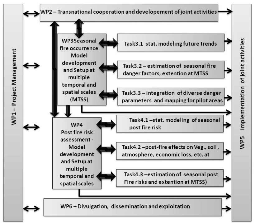
Workpackages

  • WP 1
    Project Management
  • WP 2
    Transnational cooperation and development of joint activities
  • WP 3
    Seasonal fire occurrence Model development  and Setup at different temporal and spatial scales
  • WP 4
    Post fire risk assessment -Model development  and Setup at different temporal and spatial scales
  • WP 5
    Implementation of joint activities
  • WP 6
    Dissemination and exploitation
© Copyright 2018 | Team SERV_FORFIRE